


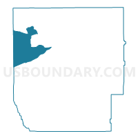
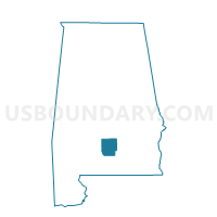
FOREST HOME, Butler County, Alabama
About
Outline

Summary
| Unique Area Identifier | 521274 |
| Name | FOREST HOME |
| County | Butler County |
| State | Alabama |
| Area (square miles) | 44.97 |
| Land Area (square miles) | 44.97 |
| Water Area (square miles) | 0.00 |
| % of Land Area | 100.00 |
| % of Water Area | 0.00 |
| Latitude of the Internal Point | 31.82214000 |
| Longtitude of the Internal Point | -86.85548110 |
Maps

Graphs
Select a template below for downloading or customizing gragh for FOREST HOME, Butler County, Alabama


Neighbors
Neighoring Voting District (by Name) Neighboring Voting District on the Map
- Allenton, Wilcox County, AL
- Annex, Conecuh County, AL
- MANNINGHAM, Butler County, AL
- MONTEREY SCHOOL HOUSE, Butler County, AL
- Old Texas/Simpkinsville Voting District, Monroe County, AL
- Pine Apple, Wilcox County, AL
- PROVIDENCE, Butler County, AL
- ROCKY CREEK, Butler County, AL
Top 10 Neighboring County Subdivision (by Population) Neighboring County Subdivision on the Map
- Lyeffion CCD, Conecuh County, AL (1,808)
- Chapman CCD, Butler County, AL (1,774)
- Forest Home CCD, Butler County, AL (1,469)
- Beatrice CCD, Monroe County, AL (1,341)
- Pine Apple CCD, Wilcox County, AL (981)
Top 10 Neighboring Unified School District (by Population) Neighboring Unified School District on the Map
- Monroe County School District, AL (23,068)
- Butler County School District, AL (20,947)
- Conecuh County School District, AL (13,228)
- Wilcox County School District, AL (11,670)
Top 10 Neighboring State Legislative District Lower Chamber (by Population) Neighboring State Legislative District Lower Chamber on the Map
- State House District 90, AL (39,991)
- State House District 69, AL (37,572)
- State House District 68, AL (36,234)
Top 10 Neighboring State Legislative District Upper Chamber (by Population) Neighboring State Legislative District Upper Chamber on the Map
Top 10 Neighboring 111th Congressional District (by Population) Neighboring 111th Congressional District on the Map
- Congressional District 1, AL (687,841)
- Congressional District 2, AL (673,877)
- Congressional District 7, AL (603,352)
Top 10 Neighboring Census Tract (by Population) Neighboring Census Tract on the Map
- Census Tract 352, Wilcox County, AL (2,040)
- Census Tract 9602, Conecuh County, AL (1,808)
- Census Tract 9533, Butler County, AL (1,774)
- Census Tract 9530, Butler County, AL (1,469)
- Census Tract 756, Monroe County, AL (1,341)